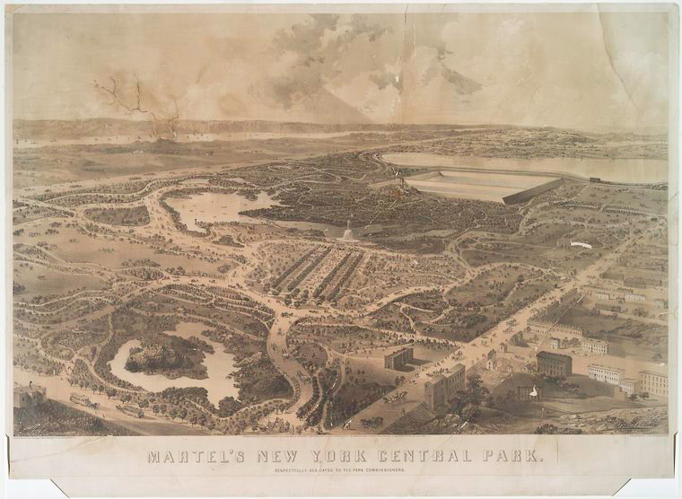
Posts by Artis Q. Wright

Mapping the Nation with Pre-1900 U.S. Maps: North vs South and Moving West

In this second part of the series, we look at pre-20th century maps covering the Civil War, westward expansion, and even the World's Fairs.

Mapping the Nation with pre-1900 U.S. Maps: Uniting the United States

Take an extensive look at some of the most notable and influential pre-20th century maps of the U.S., and the history and mapmakers behind each one.

Navigating the Library's New York City Maps

Our collection of New York City maps spans a large swath of time, tracking the growth of the city from its early days as a small North Atlantic Dutch colony to its modern incarnation as one of the capitals of the globalized world.

Looking for Langston, Du Bois, and Miss La La: An Interview with Author John Keene

An interview with John Keene: a writer-in-residence in the Library’s Wertheim Study in 2013, where he researched and wrote Counternarratives, for which he received an American Book Award and a Lannan Literary Award in Fiction in 2016.

Historic Central Park Maps

The Library's collection includes a diverse range of cartographic material including well-known topographic surveys depicting the landscape before the park’s construction as well as numerous maps published after its completion with indexes that list amenities and places of interest.

NYC Rapid Transit in Maps, 1845-1921: The Street Railroads of New York and Vicinity

We can gain a deep understanding of the development of the city’s public transit infrastructure simply by examining nine maps published between 1845 and 1921.

Survey and the City: An Imaginary Conversation With E.L. Viele

Egbert Ludovicus Viele (Vee-lee) was born June 17, 1825 in Waterford, New York. He was a member of Congress, U.S. Civil War Union Army officer and was commissioner of New York City parks from 1883 to 1884. The West Point graduate surveyed the island of Manhattan and was appointed engineer-in-chief of Central Park in 1856, and engineer of

Designing the City of New York: The Commissioners’ Plan of 1811

New York City’s wealth of good design is well known. Its streets are home to a plethora of artisans, graphic designers, fashion designers, architects, etc. who spend their days focused on creating objects, spaces, or experiences that are new, innovative and unique. These designers are often given a blank canvas of raw material—“what is”—onto which they must describe a vision—“what can be.”

Now imagine an urban designer given the monumental task of designing a plan for the orderly growth of a young metropolis. Home to 

You are here: 42nd Street and Fifth Avenue in 1857

I am at the corner of 42nd Street and Fifth Avenue. According to plate 78 of my map atlas—Williams Perris’s 1857 “Maps of the City of New York”—the massive (2) block long stone structure at the southwest corner of this Manhattan intersection is not the