NYC Rapid Transit in Maps, 1845-1921: The Street Railroads of New York and Vicinity
Like many busy New Yorkers sometimes it’s easy for me to take for granted the existence of the numerous subway, bus and commuter train lines that connect the various nodes of this amazing metropolis. However, similar to its forest of skyscrapers and unique street grid, NYC’s rapid transit system plays a crucial role in the continued success of the nation’s de facto capital of art, design and finance.
We are fortunate that the Map Division’s collection includes scores of antiquarian NYC rapid transit sheet maps which may be used by transit enthusiasts to document the beginning stages of the city’s extensive urban railway network. Yet I would argue that we can gain a deeper understanding of the development of the city’s public transit infrastructure simply by examining nine maps published between 1845 and 1921. These maps document the transformation of a humble mass transit system dependent on slow moving horse drawn omnibuses constrained by traffic into a system that had its own right of way powered by steam engines in Upper Manhattan in the more rural parts of the young city and horse drawn train cars in the densely built-up district of Lower Manhattan.
These maps also show us that most of the railroads that ran at street level beginning in the mid-1800s would eventually be superseded by elevated train lines in the final decades of the 19th century; fortunately many of these elevated trains would be replaced in the first half of the 20th century by electric powered subway cars racing a few feet below the city streets.
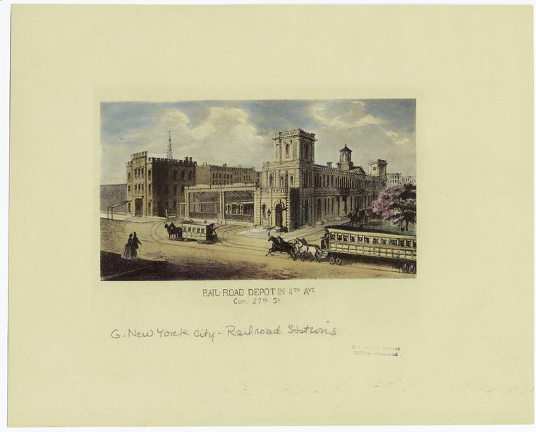
In many respects the city’s rapid transit history begins on April 25, 1831 when the state legislature awarded a charter to the “New-York and Harlaem Rail Road Company” authorizing its owners to “construct a single or double rail road or way, from any point on the north bounds of Twenty-third street, to any point on the Harlaem River between the east bounds of the Third ave...to transport, take, and carry property and persons upon the same, by the power and force of steam, of animal or of any mechanical or other power…”
By December of that same year N.Y.&H.R.R. Co. would present their plans to the city and would receive authorization from Mayor Walter Bowne and the Common Council to begin construction. Soon after the railroads owners laid tracks along 4th Ave between East 23rd St and the Harlem River, the city’s first surface railroad line would prove to be a success and within a few years it would extend southward to City Hall. Over the next thirty years more than a half dozen railroad companies would receive charters from state and local municipalities of N.Y. or N.J. to build rail lines in the metropolitan area including the New Jersey Railroad (1832), the Long Island Railroad (1834), the Hudson River Railroad (1847), the Sixth Avenue Railroad (1851), the Eighth Avenue Railroad (1852), the Second Avenue Railroad (1852), the Third Avenue Railroad (1858) and the Ninth Avenue Railroad (1858). The region’s urban railroad lines proved to be popular with New Yorkers and Brooklynites alike, Eric Homberger’s Historical Atlas of New York City estimates that by 1860 they carried more than 38,000,000 passengers annually.
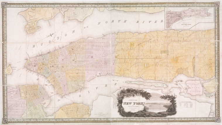
Although the focus of NYC booksellers T. & E.H Ensign’s 58 x 112 cm hand colored map is the “City of New York” (meaning Manhattan) it also includes portions of the neighboring cities of Brooklyn, Willamsburgh, Hoboken and Jersey City. Its 1:14,000 scale wonderfully depicts Manhattan’s newly designed street grid system which at the time of the map’s printing was little more than three decades old and was still for the most part a work in progress above 28th St.
It’s worth noting that this map is also a “plan” and is a clever mix of the existing quasi-rural landscape of Midtown and Upper Manhattan characterized by country roads and simple wood framed house and the proposed urban landscape described in the Commissioners' Plan of 1811. Yet if we look closely we can see the N.Y.& H. R.R. line that by the mid 1840s originated at City Hall in Lower Manhattan and moved northward along Centre St., Broome St., the Bowery and Fourth Ave before terminating approximately 7.8 miles north at the Harlem River. T. & E.H. Ensign’s map also shows the Long Island Railroad line that originated at the South Ferry dock where Atlantic Ave. meets the East River in Brooklyn.
Across the harbor the New Jersey Railroad & Transportation Co. line may also be observed at left along the waterfront in Jersey City. Note the map’s depiction of various ferry lines that crisscrossed the East River and the Hudson, thirty-eight years before the completion of the Brooklyn Bridge in 1883 and sixty-three years before the completion of the first Hudson river railroad tunnel in 1908 the city’s two largest rivers (which were major lanes of nautical transportation in their own right) still restrict the movement of its commuter trains.
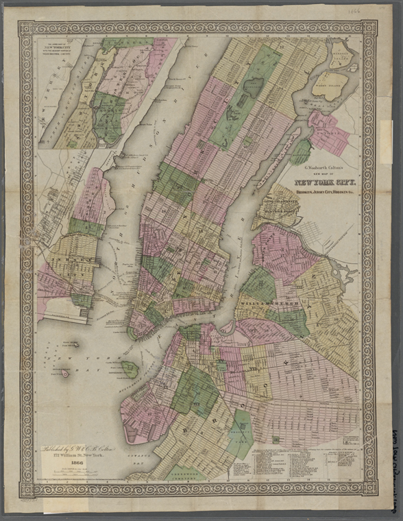
George Woolworth Colton’s 58 x 42 cm color map depicts NYC and vicinity at an approximate scale of 1:28,800 a year after the end of the American Civil War. We can see that thirty-five years after the region’s first railroad charter the cities of New York, Brooklyn, Jersey City, and Hoboken were home to dozens of small independent railroad companies that traversed their main thoroughfares. By the middle of the 19th century NYC (the boundaries of which were still limited to the island of Manhattan) had gained railroad lines that ran along most of the major avenues and as Colton’s map shows there were also crosstown lines that ran along parts of 42nd St., 59th St., Broadway, Houston and Canal St. The two oldest lines in Manhattan, the New York and Harlem R.R. and the Hudson River R.R., have grown and now connect the city with the suburban villages and towns north of the Harlem River in Westchester County.
Across the East River in the city of Brooklyn there are over a dozen street railroads the majority of which terminate at ferry stations that provided Brooklynites and residents in the the suburbs of Kings County a quick commute to places of employment in Manhattan. Similar to NYC's surface railway network, Brooklyn’s railroad lines were named after the avenues upon which they served—Fulton Ave., Flatbush Ave., Myrtle Ave., Broadway, etc. or were named after the train’s final destination—Coney Island, Green Point, Fort Hamilton or Newtown in Queens County. Brooklyn’s mid-19th century commuter railroads also connected its residents to the city’s main recreational areas- Greenwood Cemetery, Washington Park (later known as Fort Greene Park) and the city’s grandest public space Olmsted and Vaux’s Prospect Park which would be completed in 1867 one year after Colton’s map was published (A fact that would help explain why the park is drawn with such an odd shape on this map.) Train lines also provided longshoreman and laborers access to work at the Atlantic Basin, the Erie Basin and the Navy Yard.
Similar to Brooklyn, Colton’s map depicts the railroads of Jersey City and Hoboken as having lines that terminated at ferry stations connecting New Jerseyites with employment in NYC. It should come as little surprise that his map shows the Hudson River ferries as having the same names as the railroads that fed them commuters such as the New Jersey Central Railroad Ferry or the Erie Railway Ferry. However, most N.J. railroads were named after the geographic areas they serviced—the Jersey City Railroad, the Weehawken Railroad, the Bergen Hill Railroad and the Hoboken & Hudson City Railroad are a few examples.
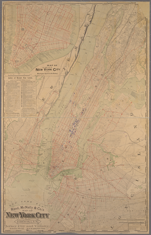
When this map was published by Rand, McNally & Co. in 1891 the famous Chicago based mapmakers had an office at 323 Broadway in Lower Manhattan. Their 108 x 68 cm color map has an approximate scale of 1:25,000 and shows the complex street railway systems that existed in the region thirteen years before the first subway line and seven years before the consolidation of the region into what would eventually be known as “Greater New York.” The map index indicates that most trolley cars were powered by “electric traction”, however a few lines still relied on “animal traction” (horses) to propel them through the streets and avenues most notably along First Avenue on the east side of Manhattan between the Lower East Side and East Harlem.
The index also lists the names (and cabin color!) of ninety-eight streetcar lines—NYC (Manhattan) had forty-one, Brooklyn and Long Island City shared forty-four lines and the Jersey City / Hoboken waterfront area had a total of thirteen train lines. By the time this map was printed NYC’s two oldest lines, the N.Y. & Harlem R.R. and the Hudson River R.R., had been acquired by Cornelius Vanderbilt and consolidated into the New York Central and Hudson Railroad and had two large inner city depots (located at the future sites of Grand Central Terminal and Penn Station) mainly used by commuters and day trippers living in the villages along the Lower Hudson Valley. Brooklyn’s oldest rail line, the Long Island R.R., still provided limited local service but was increasingly used by commuters living in the suburban towns out on L.I.
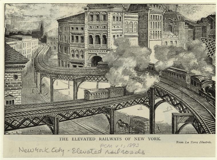
Rand, McNally & Co.'s map also shows us that by the end of the 19th century the metropolitan area was home to almost a dozen elevated railway lines operated by the Manhattan Elevated Railway, the Brooklyn Elevated Railroad and the Kings County Elevated Railroad and provided a faster alternative to the street trolley car system which was commonly subjected to the congestion and chaos of North America’s largest city that by 1900 had an aggregate population of almost 3.5 million.
Read E-Books with SimplyE
 With your library card, it's easier than ever to choose from more than 300,000 e-books on SimplyE, The New York Public Library's free e-reader app. Gain access to digital resources for all ages, including e-books, audiobooks, databases, and more.
If you don’t have an NYPL library card, New York State residents can apply for a digital card online or through SimplyE (available on the App Store or Google Play).
Need more help? Read our guide to using SimplyE.
Comments
New York and New Rochelle RR 1852
Submitted by William Bennison (not verified) on December 25, 2018 - 4:25pm
1913-1920
Submitted by Barbara Banks (not verified) on September 8, 2019 - 3:18pm
In the early 20th century,
Submitted by Ed Bacher (not verified) on September 2, 2021 - 5:51pm
Information
Submitted by Matthew Longo (not verified) on January 22, 2020 - 12:56am
Rr history. 1867. Other
Submitted by Christine Gowey (not verified) on June 17, 2020 - 7:50am
Streetcar Lines and Stops ca. 1867
Submitted by Robert Wm Astyk (not verified) on September 19, 2020 - 10:17pm
Hi Robert. The librarians of
Submitted by Carrie McBride on September 21, 2020 - 10:03am
streetcar lines in NYC 1850s to 1870
Submitted by Heidi CUSICK-DI... (not verified) on December 26, 2020 - 1:16pm
Please contact librarians in
Submitted by Carrie McBride on December 28, 2020 - 9:46am