The Ticketless Traveler
Summer Reading—It's in the Maps
Let’s face it: we are not all book-readers. For whatever reason, some of us don’t easily get absorbed by fiction plots and characters or by long form nonfiction concepts and exposition. Maybe our attention spans or the patterns of our lives don’t lend themselves to that kind of reading. But that doesn’t mean we don’t read a lot. Whether it’s cereal boxes, blog posts or news feeds, magazine or newspaper articles, recipes, or other kinds of instructions, reading is usuallly still a big part of the lives of those of us who don’t often read whole books. So don’t feel sheepish if someone asks what books are on your summer reading list—just remind them that the library has a lot to offer beyond books for recreation and edification during what we like to think of as the lazy days of summer (and all through the year!).
Come to the Library online, or when available, in person, for such non-book reading pleasures as magazines and newspapers; sheet music; recipes, DIY advice, and travel guidance (often in books, but you can simply dip into them); and my favorite—maps.
You don’t have to know how to read maps in a technical way in order to derive enjoyment from them. Seeing familiar names and features might help you indulge in nostalgia for places where you’ve spent time in the past or spur you to see those familiar places in a new way. The broad concept of literacy encompasses visual and spatial literacy, and becoming comfortable with maps by looking at maps of places you know is an ideal way to develop that sense. On the other hand, you might want to immerse yourself in explorations of unfamiliar territories to visualize them through the mapmaker’s lens of design, labels, colors, and symbols, to better understand events, issues, or trends.
Here are some suggestions of maps to read as inspiration for summer recreational activity:
Getting Close to Nature
Here’s a beauty of a Central Park map to read and explore:
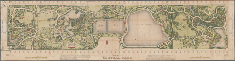
A companion publication, Central Park, the plant list of 1873, is a guide to vegetation in the park. For more recent information on trees in the park, you might want to request this Central Park, New York City 2010 map, with tree legend, when you are able to come to the Library. Or right now, check out this online map of great trees in NYC Parks, or this interactive inventory map of NYC street trees.
Hiking
See how the “foot paths” of yesteryear correspond to hiking trails of today. Note that there were railroads that made it possible for folks to come from the city to work or play in and around the tourist mountain houses of the Catskills, as seen on this 1884 map. It focuses on a few of those hotels and the surrounding trails near Kaaterskill Clove.
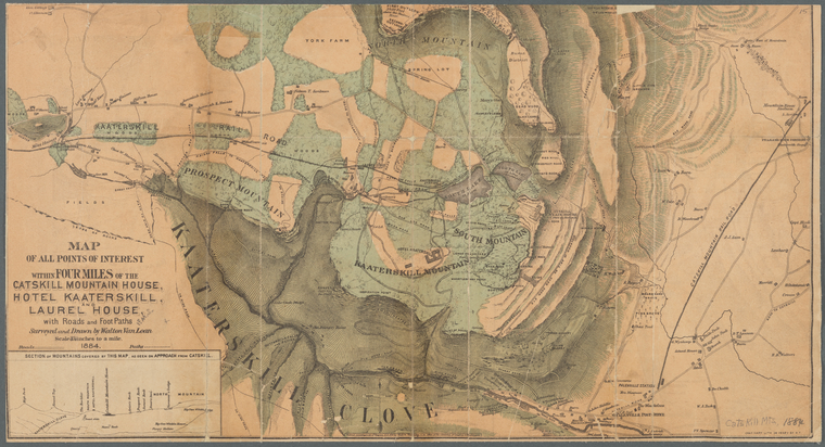
The Library also has a 2010 map of Catskill Trails. See what other trail maps worldwide are available in NYPL’s Lionel Pincus and Princess Firyal Map Division by searching the catalog with SUBJECTS:
- Hiking
- Trails
Add a place name to your search if you wish, and LIMIT to MATERIAL TYPE Map.
Right now you can view current trail maps for the New York area online by going to the site of the New York/New Jersey Trail Conference, which includes this map of an area overlapping the coverage of the 1884 map above.
You can also go to the website of the New York City Department of Parks & Recreation for maps of recommended hiking trails in NYC parks.
Cooling Off by the Water
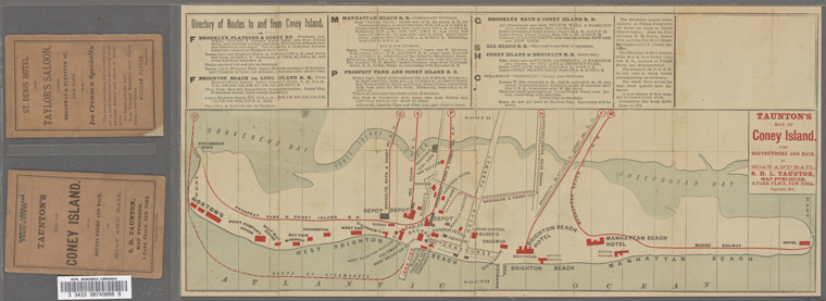
Imagine when Coney Island was more of an excursion from the city than it is today. Reading this 1879 map, with places of interest and routes and modes of travel laid out, was a good way to plan your trip there, whether by horsecar, rail, or steamboat. Reading it today is, of course, a trip back in time.
For more recent maps of waterfront access around New York City, here are a couple of suggested paper maps to request onsite in the Map Division:
For current and historical nautical charts online of coastal locations all around the country, start at this page of links from the National Ocean Service.
Biking
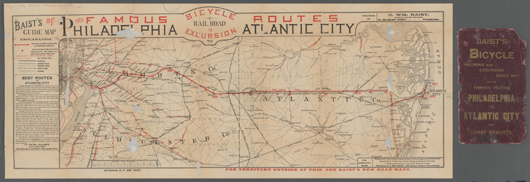
In the late 19th century heyday of the sport as a transportation mode, Philadelphians with bicycles might make a trip to cool off by the water by following this 1897 route map to Atlantic City, New Jersey. Reading it today could inspire the planning of a present-day iteration of the two-wheeled ride.
You might like to see what other cycling maps are available in the Map Division, including more recent publications. Search the catalog with these SUBJECTS:
- Bicycle touring
- Bicycle trails
- Cycling
You can add a place name to the search if you have a geographic focus, and then LIMIT to MATERIAL TYPE Map. An example of what you might find is this 2015 Denver Bike Map. Closer to home, and for immediate viewing, go directly to the city website for the NYC Bike Map 2020.
More on reading maps
- Browse NYPL’s Digital Collections for more maps to read online.
- If you’d like to go beyond spontaneous and self-guided map reading to take advantage of some direction in understanding the components of a map, a place you can start is one of our earlier blog posts on the “Elements of Cartography,” which illustrates several common elements as seen on antique maps.
- To help you delve further and get the most out of a map, the National Archives has developed a set of incisive questions to help you analyze a map as a document.
- Another blog post, on teaching American history with NYPL Digital Collections, includes an instructive example comparing two maps from the revolutionary era in New York—reading maps to add context to other historical documents.
- To help you read maps with a focused eye on the intent of the mapmaker, take a look at an in-depth online exhibition posted by Boston Public Library’s Norman B. Leventhal Map & Education Center, Bending Lines.
- And finally, if you’d like to read a book about maps, there are many available for downloading or borrowing from the Branch Libraries. For a few suggestions, see “10 Books for Map Enthusiasts to Read at Home.”
Read E-Books with SimplyE
 With your library card, it's easier than ever to choose from more than 300,000 e-books on SimplyE, The New York Public Library's free e-reader app. Gain access to digital resources for all ages, including e-books, audiobooks, databases, and more.
If you don’t have an NYPL library card, New York State residents can apply for a digital card online or through SimplyE (available on the App Store or Google Play).
Need more help? Read our guide to using SimplyE.