Archives
Elements of Cartography

In Elements, the reader is reminded that every map should have a set of common features (elements) aside from the geographic information that delineate the landscape.
And while the book is about making new maps, the elements of cartography, as they are etched, engraved, printed, hand-colored, cataloged, digitized and presented on old maps in our Digital Gallery, and in our new web map toolkit maps.nypl.org, and outlined and illustrated below, can be a source of enormous inspiration, stirring the creative juices of not only cartographers, but visual artists, designers, historians, sociologists, anthropologists and more...
Dive in further at the Library's Map Division.
Compass Rose
The compass rose tells us which way is north (not all maps orient north at top as with the image below from the Map of New England Captain John Smith's 1627 The generall historie of Virginia, New-England, and the Summer Isles ...

Scalebar
The scalebar tells us what a given unit of measurement (inch, cm etc...) indicates when applied to the map (miles, km, etc...) The scalebar on the map below, Lord Baltimore's 1635 Noua Terrae-Mariae tabula, indicates its map units as "Sea Leagues".

Representative Fraction
The representative fraction, e.g. 1/62,500 tells us that one unit (any unit) of measurement equals, in this example, 62,500 of that same unit on the planet earth. The map below, titled Mount Marcy, was first published by the U.S. Geological Survey sometime in the 1880's and reprinted in 1912. This map is a quadrangle map, indicating it covers 1/4 of a degree on the planet earth.

Cartouche
The cartouche frames out a titleblock and publisher’s information and often contain really interesting expositions related to the publication of the map, complete with the appropriate genuflecting to a king or God. The cartouche below is from John Speed's America with those known parts in that unknowne worlde... published in 1627. The scrolly shape in this example gives an indication of origins of the word cartouche, which is French for cartridge, as in bullet. Before the invention of metal or plastic casings, the cartridge was made a rolled paper package fulled with gunpowder and lead shot. Apparently, the scrolls looked like cartouches, hence the name.

Neatline
The neatline frames the area of geographic coverage on the map (in this case Virginia) and is sometimes coupled with a grid that is keyed either to an index or to the graticule (lines of latitude and longitude). In the cartouche tucked up against the neatline below, naked baby angels called "puttis" hold aloft a curtain with the title Nova Virginiae Tabula on this 1671 map, originally commissioned by John Smith.

Legend
The legend unpacks the meaning of the symbols used to depict different types of information on the map such as cities, mountains, roads etc... The legend below, from J.H. Young's New Jersey, published in 1839 indicates symbology for both the latest innovations transportation, from canals to railroads, to tried and true "common" and stage roads.

Whimsy
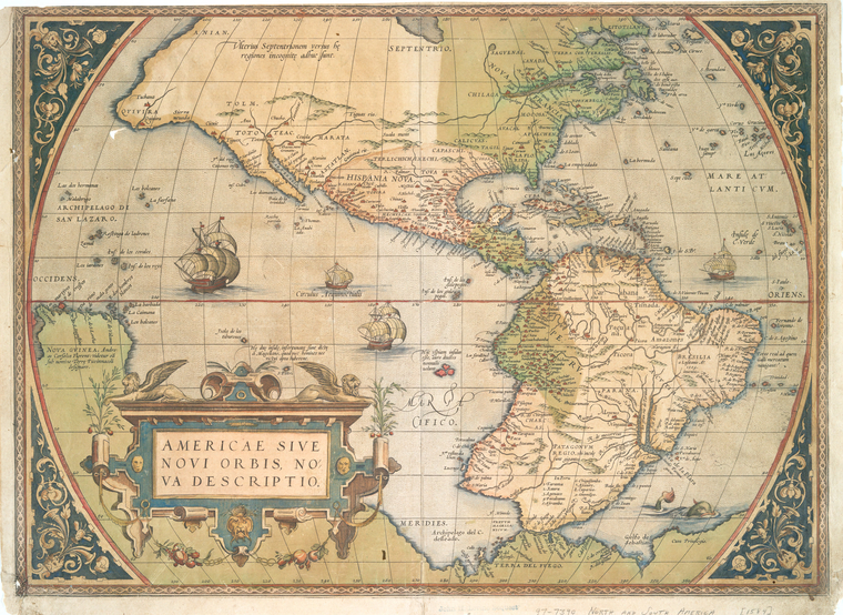
And finally, in addition to those standard cartographic elements, we have fun things appearing here an there, as if by magic, like sea dragons, and warring ships, angelic cartographers, historic and allegorical figures. These things allude, often in modern and self conscious fashion, to the makers of the maps, or the the wider geopolitical zeitgeist, and in some cases to the cosmographical order of things in the universe.
Homann, Regni Mexicani... 1759-1784:


Again, John Speed's America... 1671:

Again, Homann, Regni Mexicani... 1759-1784:

Hondius, Virginiae item et Floridae Americae... 1636:

Ortelius, Americae sive novi orbis...1573:

Hopefully, you can draw some inspiration from these Elements of Cartography!
Read E-Books with SimplyE
 With your library card, it's easier than ever to choose from more than 300,000 e-books on SimplyE, The New York Public Library's free e-reader app. Gain access to digital resources for all ages, including e-books, audiobooks, databases, and more.
If you don’t have an NYPL library card, New York State residents can apply for a digital card online or through SimplyE (available on the App Store or Google Play).
Need more help? Read our guide to using SimplyE.
Comments
Elements of Cartography Lord Baltimore's Map Date Wrong
Submitted by David (not verified) on May 19, 2011 - 1:03pm
SIgnature on Archibald
Submitted by Anonymous (not verified) on April 15, 2012 - 3:58pm