County Atlases
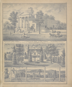
![Tonawanda Falls [Village]; Byron Center [Village]; Harris Mills [Village], Digital ID 1584322, New York Public Library Tonawanda Falls [Village]; Byron Center [Village]; Harris Mills [Village], Digital ID 1584322, New York Public Library](https://images.nypl.org/?id=1584322&t=w)
Their pages are filled not only with wonderfully detailed maps on the national, state, county, township and city level, but also with interesting, flat perspective engravings depicting local business districts, prominent estates and farms. Business directories sometimes accompany the map pages that, along with the drawings, provide a glimpse into local social and economic geography of the 19th century. They also give us an idea of who provided funding for the production of these subscription based publications.
Read E-Books with SimplyE
 With your library card, it's easier than ever to choose from more than 300,000 e-books on SimplyE, The New York Public Library's free e-reader app. Gain access to digital resources for all ages, including e-books, audiobooks, databases, and more.
If you don’t have an NYPL library card, New York State residents can apply for a digital card online or through SimplyE (available on the App Store or Google Play).
Need more help? Read our guide to using SimplyE.

Comments
bad link
Submitted by Barbara Snow (not verified) on June 28, 2011 - 5:33pm