Conflict/Resolution and Changing Geographic Realities in the Peace of the Map Division
Newly installed in the Map Division’s exhibition case are three not-so-new maps demonstrating the role that maps play, years after their informative, current-events function, in documenting histories of changing boundaries. Looking back, we can see not only cartographic snapshots of former times but also transformed geopolitics that may hold the seeds of new conflicts—the unintended consequences of treaties that did more than draw new lines and paint different colors on subtly subjective maps.
Here is a preview of the maps that you can come to see in person in the Map Division.

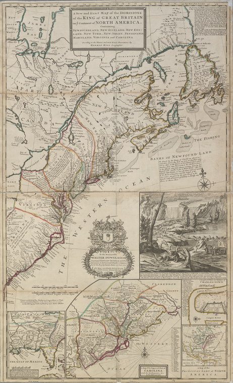
A new and exact map of the dominions of the King of Great Britain on ye continent of North America 1715 [with changes to 1731], Herman Moll’s map, not only illustrates industrious beavers but also reflects provisions of the Treaty of Utrecht of 1713. Boundaries and notes indicate new agreements about waters and lands accessible to the French in this bountiful fishing area.

John Disturnell’s Mapa de los Estados Unidos de Mejico, 1848, is the 14th edition, in Spanish, of a series of maps chronicling battles that led to the Treaty of Guadalupe Hidalgo, which established a new U.S.-Mexico border. (This image, of an 1847 edition of the map, is shown courtesy of the Library of Congress, Geography and Map Division because NYPL’s 1848 edition in our exhibition has not yet been digitized.)

The Rand McNally Map of New Europe, 1919, with “Summary of the Treaty of Peace,” focuses on the newly formed European countries resulting from the Treaties of Versailles and Saint-Germain-en-Laye that followed World War I. (This image is shown courtesy of Toronto Public Library because NYPL’s copy in our exhibition has not yet been digitized.)
Beyond content, these three maps, produced in the eighteenth, nineteenth, and twentieth centuries respectively, provide an easily viewed progression of changing styles of cartography, from the decorative to the unadorned.
For further reading on these maps and mapmakers and their historical context, here are a few places to start:
- The Cartographer and the Literati: Herman Moll and his Intellectual Circle, by Dennis Reinhartz, 1997
- “John Disturnell’s Map of the United Mexican States,” by Lawrence Martin, in A La Carte, compiled by Walter W. Ristow, 1972
- Mapping the First World War by Peter Chasseaud, 2013.
Since the Map Division was restored and renovated as The Lionel Pincus and Princess Firyal Map Division in 2005, a new, permanent exhibition case has been anchored along the north wall of the reading room for displays such as the one described above. This enables the staff, with the help of the library’s able conservators and exhibition installers, to show off examples of the library’s cartographic treasures that shed light, as primary resources, on their makers’ views of the world in their own time. These small exhibitions change every few months. They are well worth a look, not only for the maps themselves, but also for the background information included in label text researched by our curator, and for the lovely and (usually!) peaceful ambiance of our restored reading room. We welcome you to stop by in the Map Division, Room 117 of the Stephen A. Schwarzman Building, to see them.
In years past (until the early 1980s), the Map Division staff would display maps in a small, temporary exhibition case in the hallway outside the reading room, along with a few framed maps hung on the wall above the case. But the “blockbuster” exhibitions have been those in the library’s larger, dedicated spaces, where maps have played a starring as well as supporting role. One can still get a taste of some of those past, library-wide exhibitions through associated publications and online versions. Connect to this Research Guide list for links to NYPL exhibitions of the past that have featured significant cartographic content.
Read E-Books with SimplyE
 With your library card, it's easier than ever to choose from more than 300,000 e-books on SimplyE, The New York Public Library's free e-reader app. Gain access to digital resources for all ages, including e-books, audiobooks, databases, and more.
If you don’t have an NYPL library card, New York State residents can apply for a digital card online or through SimplyE (available on the App Store or Google Play).
Need more help? Read our guide to using SimplyE.