Using Maps for Genealogy Research, Part 4: Topographical Maps, and County Maps and Atlases
Genealogists seek records that describe names, places, and dates. Maps describe places and their names at a given point in time and, sometimes, even record the names of people. Unsurprisingly, then, maps are very useful tools for genealogists.
The New York Public Library Lionel Pincus and Princess Firyal Map Division is home to 433,000 sheet maps, and 20,000 books and atlases published between the 16th and 21st centuries. The collections range in scale from global to local, and support the learning and research needs of a wide variety of users. This post, Topographical Maps, and County Maps and Atlases, is the fourth of a five-part series that describes some of the ways maps can be used for genealogical research.
- Finding records
- Fire insurance maps: exploring place and time
- Place of origin and immigration stories
- Topographical maps, and county maps and atlases
- Gazetteers and finding maps at The New York Public Library
Here, we look at topographical maps, and county maps and atlases. Fire insurance maps, reviewed in part 2 of our series, do a very good job of describing towns, cities, and sometimes villages, and the built structures in those communities such as roads, houses, canals, and railroads. Topographical maps add more detail to that picture, and county maps and atlases describe areas that might not be recorded by fire insurance maps. Taken as a whole, the three different kinds of maps are a rich source of information about our ancestors.
Topographical maps
Melinda Kashuba defines a topographical map as one that "describes physical features on the surface of the earth," the land—geographical features like mountains, rivers, lakes, and the coastline—but also man-made features like buildings, roads, railroads, and canals. Topo maps, as cartographers and map librarians often refer to them, tend towards accuracy, and are made using survey instruments, plane tables, field notes, and photography. They may be large in scale, and so rich in detail. Historically, topographical maps have been drawn by different public agencies: the General Land Office, the War Department, the Coast Survey and, since 1879, the U.S. Geological Survey (U.S.G.S.).
-
locate cultural features: churches, cemeteries, fence lines, ruins, boundaries, buildings
-
search for place names
-
study migration for connections between places: trails, canals, roads and railroads
-
find, in some cases, maps that show property boundaries, which lead to property deeds, tax, and probate records
-
measure distances between settlements
-
describe the physical landscape: Is it forested? Mountainous? Rural? Urban? Served by roads and/or railroads?
-
see how the landscape impacted our ancestors' lives. For instance, what kind of work did they do? Were they farmers, coal miners, ranchers?
-
see battlefields that might shed light on our ancestors' military experiences, in the Civil War, for instance
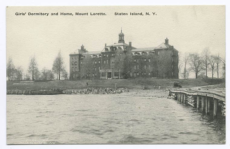
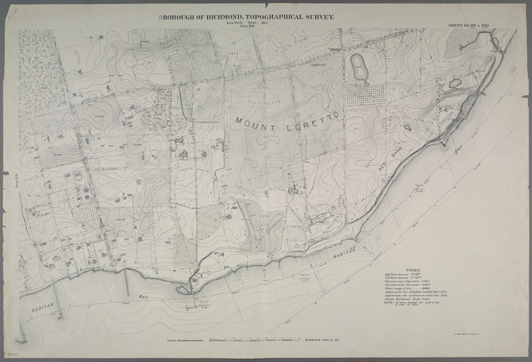
Sheet numbers 99 and 100 from the Borough of Richmond, topographical survey (1906-1913) include Mount Loretto, Red Bank, and Princes Bay Lighthouse in Staten Island. The map describes natural features including land elevation, fields, woodland, rivers, and the coastline, and manmade features; roads, property boundaries, and cultivated fields. Buildings are described in detail: what they are made of (stucco, brick, etc.), dimensions, use (barn, dwelling, garage), or even by name. St. Elizabeth’s Home [for Girls], on the grounds of the orphanage and vocational school Mount Loretto, Mission of the Immaculate Virgin, was the girl’s dormitory opened in the 1890s.

A fire insurance map of 1907 describes the orphanage, founded by Father Christopher Drumgoole in 1883, in great detail, identifying buildings including St. Joseph's Trades School, the Church of St. Joachim and St. Anne, various dormitories, a summer house, an infants' home, the Blind Asylum, St. Aloysius School, a shoe factory, a bakery, a kitchen, a fire station, and more.
The topographical map adds to the picture, as it describes the landscape in which the building is set. To the North of St. Elizabeth’s, we see the rest of the orphanage buildings, the hilly Mount Loretto, to the South Raritan Bay into which juts a wooden dock—perhaps a point of contact for the orphanage? To the West is an area of swamp, but surrounding much of the orphanage are cultivated areas including orchards, and roads that are described as made of dirt or cinder. To the East is the Princes Bay Lighthouse.
Viewed together, both maps—along with photographs, oral histories (see the comments section of this NYPL blog post), and pages from the census—create a powerful narrative of great interest to anyone whose ancestor was raised in the orphanage.
Mount Loretto ceased to be an orphanage in the 1980s and, sadly, St. Elizabeth's was destroyed by fire in 2000.
Cadastral maps

It identifies by name the European settlers of Watertown and the first people to own property there, including one John Whitney, born Middlesex, England (1589-1673). According to probate records for Middlesex County, Massachusetts, John Whitney left land to his sons John Whitney (1621-1692) and Richard Whitney (1624-1719) (April 3rd, 1673, 4:86-88), property that included "beever brook medow" and "plaine meadow" in Watertown. Bond's map shows where that land was and confirms who owned it. The map not only names the three Whitney men and the boundaries of their property, but also identifies a topographical feature, Whitney Hill, which occupies an area now known as Whitney Hill Park.
Like all good genealogy sources, this map poses new questions that suggest new avenues of inquiry. Is this hill named for the Whitney family, for instance? What records might answer that question?

County maps
The middle and later parts of the 19th century saw the development and rise in popularity of county maps and atlases. Paid for by subscription, county maps and atlases were cadastral (or plat) maps that described property ownership—and much more—in counties and the cities, towns, and villages therein.
County maps were produced in the years before the Civil War. Map of Ontario County, New York : from actual surveys / by S.N. Beers, assisted by D.G. Beers of 1859 is typical. Measuring almost 5 feet by 5 feet, this single sheet map includes a survey of the county that records the location and names of owners of property in that county, along with boundaries, roads, canals, rivers, railroads, factories, cemeteries, churches, and other prominent buildings. Inset are detailed maps of the towns and villages of the county, along with business and resident directories (usually the subscribers to the map), and a handful of illustrations of the homes and businesses of subscribers, along with churches and other prominent local buildings. These are rich sources of genealogical data, beautifully describing names and places at a given point in time.

According to Walter R. Ristow, in his book American Maps and Mapmakers: Commercial Cartography in the Nineteenth Century
"the popularity of county land ownership maps, of which some 350 were produced between 1851 and 1860, reflected the administrative and political importance of the county and towns in the lives of Americans." (403)
County atlases
A single map, no matter how large, can only hold so much information. And, as Ristow notes, "the wall map was difficult to handle and examine and was subject to rapid wear and attrition." (403).
Seeking new markets, and following developments in printing technology, the years following the Civil War saw the publication of county atlases. County atlases could contain all of the information found in a county map, but also added county, town, and village histories; biographies and portraits of prominent citizens and subscribers (often puff pieces); and more illustrated content. Whole pages could be given over to maps of towns and villages, and detailed lists of subscribers, as well as advertisements and, later, photographs of homes and people.
The Illustrated Historical Atlas of Erie Co. New York included:
- A history of Erie County
- A list of county officers, useful if your ancestor was a local official
- Histories of individual towns in Erie County
- Church, social, and educational histories
- Illustrations of historic buildings, and subscriber homes and businesses
- Portraits of influential citizens and subscribers
- Advertisements
In addition to portraits and information about property, there are brief biographies of subscribers who do not feature elsewhere in the atlas. For instance:
Daniel Hall, born in 1833 in Oneida County, N.Y., came to Buffalo in 1871, and to Tonawanda in 1874. He married Mary Sagendorf in 1859. He is dealer in groceries, provisions, flour, feed &c. At Tonawanda, N.Y. (182)
The Library's collections include hundreds of county maps and atlases, a number of which have been digitized. Fire insurance maps form part of a research arsenal that might be called urban genealogy resources. County atlases that describe smaller towns and villages, for which there are no fire insurance atlases, offer a valuable source of information for researchers exploring the history of people and property.


Later county atlases include photographs and other fasciniating genealogical tidbits. The Standard atlas of Woodbury County, Iowa, published by George A. Ogle & Co. about 1902, is typical of the genre and includes:
: S. Boyles")
- photographs of subscribers and their homes
- advertisements for local businesses
- a plat map describing property ownership
- biographies of subscribers, which includes information about when they came to Woodbury County
Pictured is one S. Boyles, full name Sanford Boyle[s], a farmer, born March 1859 (according to the 1900 U.S. Census), in Kansas. The same census tells us that his wife Mary was born 1864 in Iowa, and their children are Edward, born 1891; Myrtle, born 1895; and Sylvia, born 1897. It seems likely the little girl in the picture is one of his daughters.
: S. Boyles biography")
Plate 51 of the atlas describes Boyle's property in Lakeport Township, Woodbury County, east of the Missouri River and Nebraska. Boyle's home overlooks the Sand Hill Lake Bed, which intersects his land. The owners of the properties surrounding Boyle's farm are identified. and it's likely many are his neighbors. Elsewhere in the atlas, Boyle's biography states that he came to Woodbury County in 1878. This is important information for a genealogist trying to ascertain the whereabouts of an individual at a given point in time.
![Plate 51, Lakeport [detail] standard atlas of Woodbury County, Iowa](https://live-cdn-www.nypl.org/s3fs-public/img-4662_2.jpg "Plate 51, Lakeport [detail] Standard atlas of Woodbury County, Iowa / George A. Ogle, and Company (1896/1902 ?)")
Previous, Part 3: Place of Origin and Immigration Stories
Next, Part 5: Gazetteers and Accessing Maps at The New York Public Library
Read E-Books with SimplyE
 With your library card, it's easier than ever to choose from more than 300,000 e-books on SimplyE, The New York Public Library's free e-reader app. Gain access to digital resources for all ages, including e-books, audiobooks, databases, and more.
If you don’t have an NYPL library card, New York State residents can apply for a digital card online or through SimplyE (available on the App Store or Google Play).
Need more help? Read our guide to using SimplyE.